Editing network Shapefiles using QGIS
-
In the Layers panel, right-click on your network layer, and select Toggle Editing.
Figure 1. Editing disabled 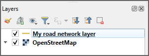
Figure 2. Editing enabled 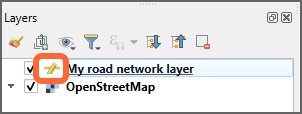 A yellow pencil symbol appears on your network layer to show that the editing mode is on.
 -
To select sections of the map, in the Attributes Toolbar, select Select
Features, and select Select Features by Polygon or Select Features by Freehand.

- If using Select Features by Polygon, click to draw a polygon around a large section of your network which is not required.
- If using Select Features by Freehand, click to start drawing a polygon, move the mouse to draw a shape, and click again to complete drawing the polygon. If there is any issue with the drawn polygon, draw another to the side of your network layer area.
- Once the area to be deleted has been selected, proceed to step 4.
-
To select individual roads, in the Attributes Toolbar toolbar, select the Select
Features tool, and then Select
Feature(s).
- To delete sections from a road if the whole road is not required, select the road, and select .
- Click and drag the mouse to draw a line across the road where it needs to be split. Click again to confirm the line, and then right-click to split the line at the point where the line crosses the road.
- If the split is not correct, select .
- Once the split is where required, proceed to the next step.
-
In the Attributes Toolbar, select Delete Selected to remove highlighted roads.
 Repeat as many times as required to remove all unnecessary
roads.
Repeat as many times as required to remove all unnecessary
roads.

Move the map and zoom in and out to make the process easier. - It may not be possible to complete all edits in one session. To save changes, in the Layers panel, right-click on your network layer and select Save Layer Edits, right-click on Toggle Editing, and save the changes.